GPS emergency locator signs improve safety on Winneshiek County trails
With the 2012 completion of Trout Run Trail and the 2016 completion of the Freeport trail extension, and plans for a Dry Run Trail connector between these two, the joint city and county board has developed a new way to improve safety on Winneshiek County's trail systems.
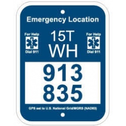
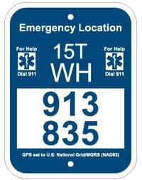
Working with local volunteers, the board has developed a GPS-based emergency locator sign system for the network of trails. County GIS Coordinator Jon Lubke and former dispatch supervisor Jon Pankow have provided support for the project. GPS signs have been installed along the trail system to give users bearings on their locations. Then can relay information to emergency responders in case of an accident or emergency situation.
The white and blue signs will display GPS coordinates that will allow first responders, ambulance crews, police and fire department members and others to quickly find someone who has been injured on the trail. Based on a national standardized system, the signs are designed to provide critical and consistent information to emergency personnel.
In an emergency situation, trail users should call 911 and tell the dispatcher the six large numbers on the nearest GPS sign. Dispatchers will be able to quickly transmit the location to multiple emergency relief agencies in the county.
Funding for the signs comes in part from the Decorah Rotary Club and the Winneshiek County E 9-1-1 Board.
Additional questions may be directed to Decorah Parks & Recreation Department at (563)-382-4158 or Barbara Schroeder at Winneshiek County Conservation at (563)-534-7145.
Site designed and maintained by Iroc Web Design Services©.
Your Small Business Web Design Solutions.™


