Making Winneshiek County's bike trails safer
When there's an emergency on the Prairie Farmer Trail or the Trout Run Trail, police and ambulance crews want to get to the scene as quickly as they can. But finding the scene of a bicycle accident, for instance, is more challenging than locating a car accident on a particular road.
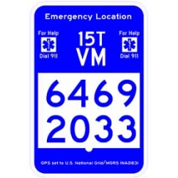
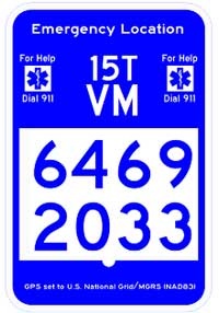
A Decorah Boy Scout is working on an Eagle project that would give emergency workers GPS coordinates that would lead them to the scene. Tyler Lubke tells decorahnews.com he has mapped half of the Prairie Farmer Trail already and was intending to complete the work over the weekend, depending on the weather.
Tyler will then wait for approval of signs to be put up along the trail that would show the GPS coordinates of that location. He explains that the whole world is split into a grid, so that system can be used to assign numbers and letters that give coordinates to every location on earth.
Winneshiek County Conservation Executive Director Barb Schroeder calls Tyler's efforts "an absolutely wonderful project." She says the GPS mapping is becoming more important because the county's recreational trails "get a lot of out-of-town users." Those tourists could call 9-1-1 in an emergency and give a dispatcher the GPS coordinates from the signs. The dispatcher then could call up computer information about the trail and advice emergency crews how to get to a location in the quickest way.
Winneshiek County Sheriff Lee Bohr says the 9-1-1 Board has discussed the project and has already promised to pay for the signs.
When the Prairie Farmer Trail GPS project is completed, Schroeder says her agency will turn its attention to the Trout Run Trail, hoping that another Boy Scout would want to do that project as an Eagle Scout project. Schroeder says the only hold-up right now is that county officials are waiting to hear back from a GPS expert in Waterloo who has been pressing state officials to adopt a uniform statewide system.
Site designed and maintained by Iroc Web Design Services©.
Your Small Business Web Design Solutions.™


